HIGH 5s
5 STAGE FM TO LEH
The Hell Ultra-480 km might appear formidable to some and downright crazy to most, but for those of us who wish to get a taste of running at high altitudes, we introduce the great Himalayan stage run – The High 5’s. Run five full marathons on five consecutive days from Manali to Leh on the toughest & the highest road in the world. The idea behind ‘The High 5’s’ is to celebrate running not only as a sport but also as a lifestyle; to provide a platform for runners from all around the World to meet, run together, and share their experiences of surviving in the toughest conditions, overcoming barriers.
On one of the remotest Indian highways with the most unpredictable conditions and the most beautiful landscapes the country has to offer, The High 5’s is a festival for you.

PRE RACE SCHEDULE
- ARRIVAL IN SOLANG: 20 JUNE, 2026
- ACCLIMATISATION
- 20 JUNE: HIKE TO ANJANI MAHADEV TEMPLE, HIKE AROUND SOLANG VILLAGE & VALLEY
- BIB EXPO & RACE BRIEFING: 21 JUNE, 2026
- RACE START: 23 JUNE, 2026 AT 0400 HOURS
RACE COURSE

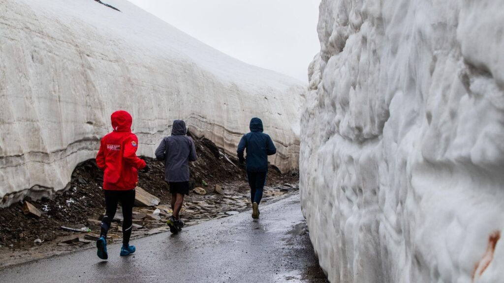
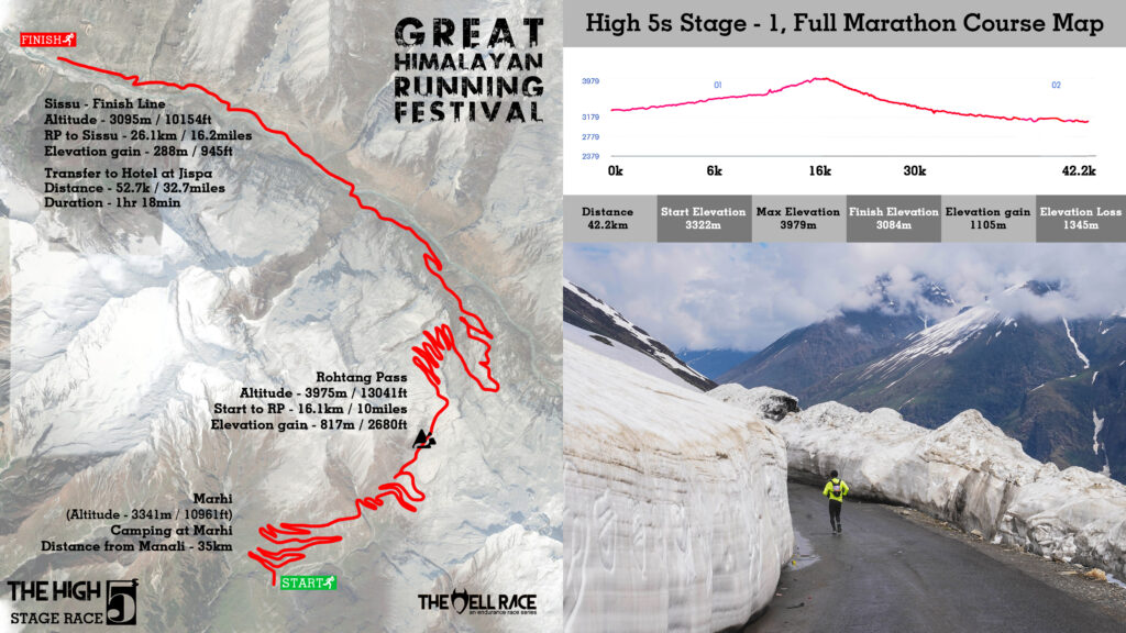
STAGE 1: THE GATEWAY – ROHTANG LA
23 June , 2026
The first day of the High 5’s is an introduction to the hell you have signed for the next five days. The first day requires you to cross the longest road distance (14 km traverse) through a mountain pass on this highway. This is the day when you get your real shot at acclimatization in the race. You may face the severest of uncertainties.
- Start: MARHI , 3341 M / 10961 ft | 06:00 HRS
Transfer to Marhi from Manali one day before the race by vehicle (35km/21.7miles, travel time approx 1:30 hrs) - Start to Rohtang La – 16.1 KM / 10 Miles | Elevation gain: 817m D+ / 2680 ft
- Highest Altitude: 3979 m / 13054 ft
- Total Elevation Gain: 1105 M / 3625 ft
- Finish: Sissu, 3074 m / 10085 ft
- Transfer to hotel at Jispa: 52.7 KM (Travel time approx 80 mins)

STAGE 2: THE PURGATORY – BARALACHA LA
24 June, 2026
The second day is a progression through the gateway you crossed in Stage 1. It gets tougher and higher, and the lungs start gasping for Oxygen. It keeps getting better though – you start from the mind-rolling turns of the Gata Loops and climb up to the Baralacha La. Suraj Taal – the pristine lake by the pass is a solace on this journey that brings you to Sarchu.
We stay in basic tented accommodation here in Sarchu. The water here freezes, and the toilet pits could be dry.
- Jispa to Start line: 30km/18.6miles (Travel time approx 30min)
- Start: Zing Zing BAR 4320 m (0600 HRS)
- Start to BARALACHA LA: 15.8 KM / 9.8 miles | Elevation Gain: 685m D+ / 2247 ft
- Highest Altitude: 4915 / 16125 ft
- Total Elevation Gain – 1644 m/ 5394 ft
- Finish: Sarchu 4694 m / 15400 ft
- Transfer to Accommodation: Sarchu- 25.4 KM (Approx travel time 46 min)
STAGE 3: BREAKING THROUGH THE TWIN TOWERS | NAKEE LA – LACHUCHUNG LA
25 June , 2026
The High 5s get further high – not just once but twice as the 3rd stage takes you through an entirely different world. Mountains here are bewildering – of magnificent shapes and sizes, carved by the snow, wind, and water. The landscape gradually transforms into canyons. We stay at a tented accommodation in Pang. Oxygen gets further thin and we spend the night with the best we can get in this part of the world – magnificent night skies and food.
- Start: Gata Loop base 4160 M | 0600 HOURS
- Sarchu to Start line: 31km/19miles (Travel time approx 45min)
- Start to Nakee La: 20.2 KM / 12.5 miles | Elevation Gain: 932m D+ / 3057 ft
- Start to Lachung La: 32.1 KM / 20 miles | Elevation gain: 1348m / 4422 ft
- Total Elevation Gain: 1348 M D+ / 4422ft
- Highest Altitude: 5082 / 16673 ft
- Finish: Pang 4774 m / 15662 ft
- Transfer to Accommodation: Pang – 12 KM / 7.5 miles (Travel time approx 30min)

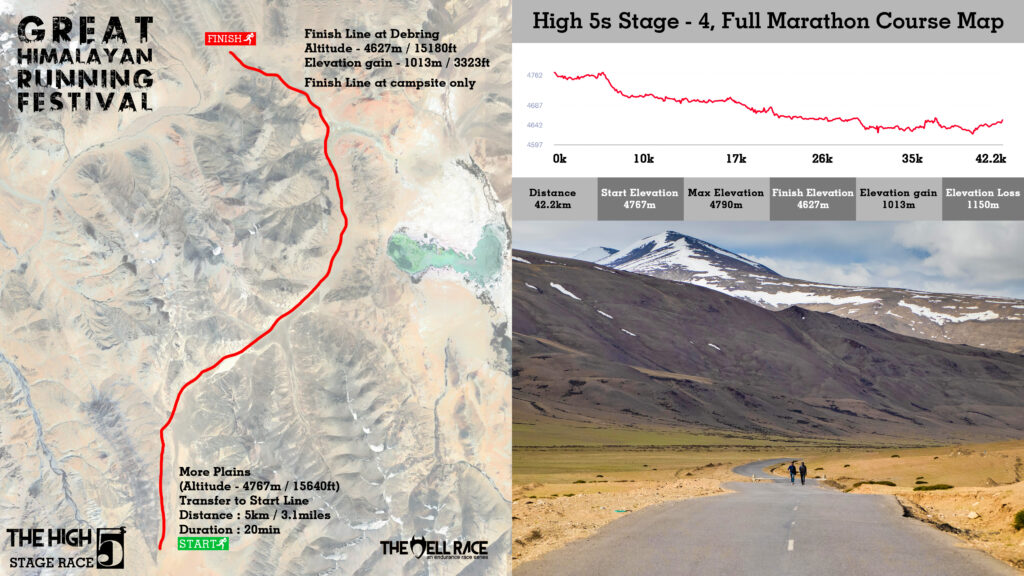
STAGE 4 – THE SAVIOR | MOREY PLAINS
26 June , 2026
With the advent of the 4th day, you gain some respite. This is the flattest course of High 5s. We start from a little above Pang, in the Morey Plains, and finish at Debring, in Morey Plans. Morey Plains is an embodiment of the infinite. After 4 days of gorgeous valleys and grand mountains in eyesight everywhere, there comes this plain spread out till the foot of mountains as far as the human eye can see. Tonight, we camp again in a makeshift accommodation. Oxygen levels do not get any better but the walk into the plains is what you would cherish the most.
- Start Morey Plains 4767 m / 15640 ft
- Pang to Start line: 5km/3.1miles (Travel time approx 20min)
- Total Elevation Gain – 1013 m D+/ 3323 ft
- Finish – Debring 4627 m / 15180 ft
- Highest Altitude: 4790m / 15640ft
- Transfer to Accommodation: Camping at Debring
STAGE 5: THE EXIT | TANGLANG LA
27 June, 2026
For one last time, before you get to the finish line, the High 5s get higher, better, and bitter. You will be going above 5300 meters. Tanglang La is infamous in the GHRF circuit – for its unpredictability. Everything here changes in a snap of fingers – the O2 saturation, the wind pressure, the temperatures, and the snow.
You cross through the pass, climb down and finish at Rumtse. Rumtse is 80 km away from Leh – our final destination. You will be ferried to the hotel accommodation and we celebrate the last 5 days of running in this part of the Himalayas in Leh city.
- Start: Debring 4627 m / 15180 ft
- Debring to Start line: 3km/1.8miles (Travel time approx 10min)
- Start to Tanglang La: 22.1 KM / 13.7 miles
- Elevation gain: 1026m / 3366 ft
- Highest Altitude: 5319 m / 17123 ft
- Total Elevation Gain: 1142 m/ 3747 ft
- Finish: Rumtse 4351 m / 14275 ft
- Transfer to Accommodation: Leh – 80 KM / 49.7miles (Approx travel time 01:30 hrs)
